There is a pleasure in the pathless woods,There is a rapture on the lonely shore,There is society, where none intrudes,By the deep sea, and music in its roar. I love not man the less, but Nature more. -Lord Byron
Showing posts with label crystal crane hot springs. Show all posts

Saturday, September 17, 2016

CENTRAL OREGON LOOP: Painted Hills, John Day Fossil Beds, Fall Mountain Lookout, Steens Mountain Wilderness

Our quarters for the evening.

Dreamy Dream Dream.... sigh...

Yes please! Gosh this place was incredible!

Thank you beautiful Oregon and hard workers that built these amazing structures in the 30s!

Cheeesh!!!

Painted Hills, some jerk face ran up the side, big troubs. 

Yikes what a gorgeous view! Interior and Exterior :)


Night walk view.


Dreamy.


Strawberry Mountains love.

Big Indian Gorge

Kiger Gorge.

Wildhorse Lake besos.


East Rim Alvord Desert Lookout ladybug.

Sunday, March 15, 2015

Smith Rock State Park to Crystal Crane Hot Springs/Harney County backroads and bone hunting, Stinking Water Creek Area, Valentines Day weekend, 2015.

Destination Crystal Crane Hot Springs, one of our favorite places in Oregon. We always change up the stops on the way to Crystal Crane, as it is a 7 hour drive, and there is just so much good stuff to see in Central and Eastern Oregon. We had such awesome weather for February, so we decided to get a few hikes in. First stop, Smith Rock State Park in Terrabonne, Deschutes County. Here is a fun video of the the Misery Ridge Loop hike that we did. https://www.youtube.com/watch?v=bBWpb5Pl3cc. The dogs did pretty well considering the incline and the heat today, but the water break on top was definitely anticipated! This is such a gorgeous area, there were a lot of beatiful water fowl, and we saw the world's largest goose at the top of a ridge. At first we thought it was Kevin from "UP", by the size of the thing. Good for him.

Smith Rock before we started Misery Ridge Loop Trail.


The traditional Maggie and Mom pose mid kiss.I also got to try out my new pack today! Been waiting a few years for the right one to show up at the right price and I took the plunge on a great deal from Sierra Trading Post. http://www.sierratradingpost.com/mountain-hardwear-napali-50-backpack-internal-frame-for-women~p~3232x/?filterString=s~mountain-hardware-backpack%2F&colorFamily=02. I used an extra 45 percent off coupon I got from their dealflyer emails, and got the pack for 79 bucks, down from the original $190! And I absolutely love it. I got the 50 liter, thinking it may be too big, but its just right! I even use it on day hikes because it is so lightweight and convenient to pack with the roll top and bottom, top and side access zippers. Honestly the best purchase I made this year.


Maggles looking down valley about a quarter way up the trail.


Monkey Face from the lee side of misery ridge.


Don't ever make us do that again!


Back Seat Driver

Smith Rock State Park on a beautiful February day.

Next on our trip was Crystal Crane Hot Springs, via whatever random dirt road Tim could find. We ended up making it there by 7pm, with time to stop and stock up at the Burns, OR Safeway. We got set up in our cabin, and soaked and played trivia games and had a wonderful time. The next morning we took a short drive in to the teeny tiny town of Crane, OR. And ventured down some dirt roads to find some bones and look at some eagles (7 dollar goodwill binoculars sure came in handy).


I suppose this is the vortex of "Stinking Water Creek Area". It wasn't too stinky, but you could tell how many different critters have been here for the water. Still couldn't believe this weather!

Just showing off my MEC short gaitors that I bought in Edmonton. I am a big fan of these. None of the big bulkiness of full sized gaitors, and they still keep all bits and water out of your boots. They are worh every penny!

This is my happy place. This is my slice of heaven. Crystal Crane Hot Springs, we come here several times a year, it is worth the 7 hour drive as we always make a road trip out of it and stop at holes in the wall, and bone hunting nowheres throughout central and eastern Oregon. Dog friendly cabins, private tubs if you'd prefe, and a community kitchen/common area.


Crystal Crane in all its glory.


Some treasures we found in the Stinking Water Creek Area just east of Crystal Crane Hot Springs, near the town of Crane itself, off a forest road.
This is the happiest 11 year old bassador you are going to find in Oregon today.
Go Tigers.

This is the general area of random roads that Tim took to get us to and from Crystal Crane this time. It's always a new adventure. Perhaps the road will be there, perhaps it won't. And you'll probably pass several boarded up mini towns that appear to be a film set for a Rob Zombie film. You just never know what will come next.


Just needs a little paint.


Monday, July 28, 2014

SPARKS LAKE: Cascade Lakes Highway; STEENS MOUNTAIN LOOP: Highway 205, Frenchglen

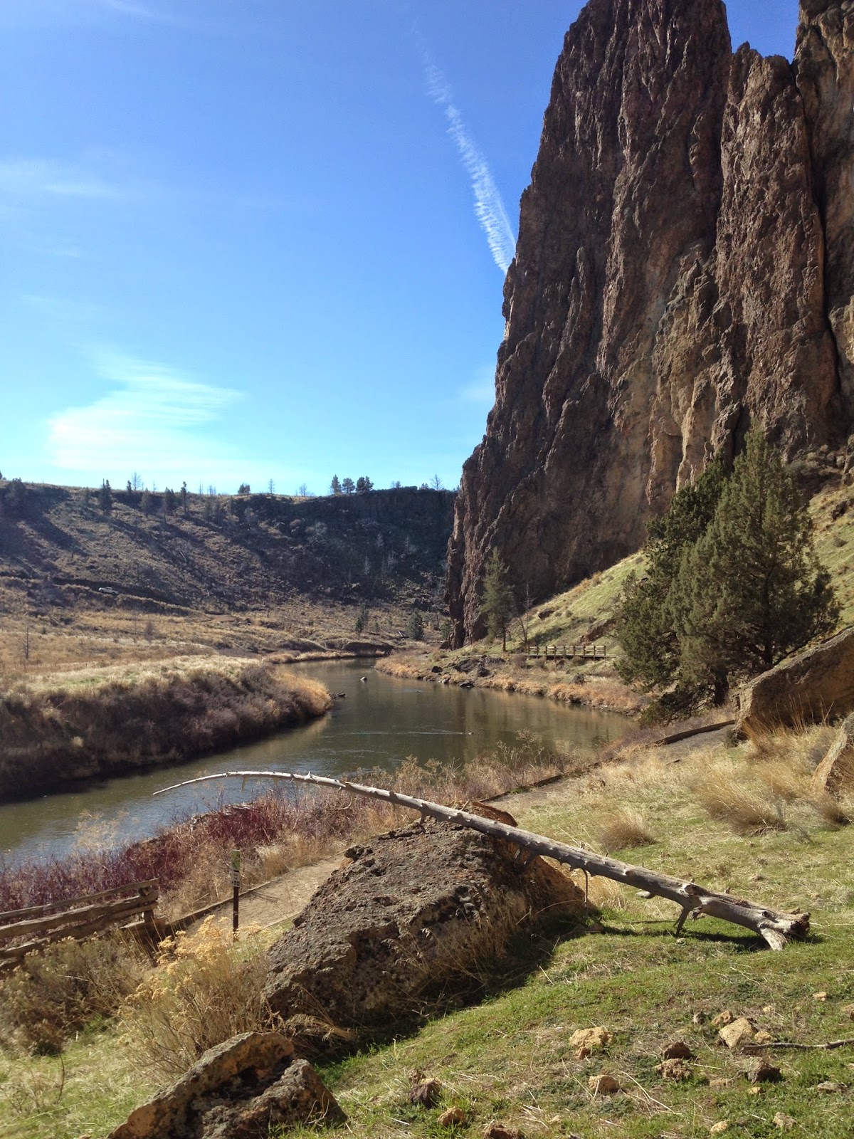
Click the link for a map of the Cascade Lakes National Scenic Byway, just a short jaunt outside of Bend, and worth the views alone. The first several photos are from our stop at Sparks Lake, it is one of my favorites off of the byway. There is a 2.8 mile hiking loop, very easy, with several gorgeous views of the lake. This would be a magical place to Stand Up Paddle Board (SUP) or kayak.  There several pull-in camping spots on the west side of the lake, and just a few down the boat ramp road, near the main body of the lake.

They call this spot the "viewpoint". So if you park in the main lot near the boat ramp (FYI , take the road on the left to head down a gravel road to the boat ramp and trail access). Park here, and when you hike the loop, keep an eye out for the "viewpoint" sign, so you don't miss your turn!
Here is another good link for the Sparks Lake hikes:


Not sure what this is right now, working on it.

Only 1.6 miles to Davis Canyon from the main lot.
One of the many ominous lava canyons along the short hike.
We headed east from Bend to spend a night at Crystal Crane Hot Springs. (My favorite place), http://cranehotsprings.com/
And Tim wanted to do the Steens Mountain Loop which we've been trying to see for years, but the loop is only open about 3 months out of the year (best time July-October), the road is shut down during most of the winter. The 59 mile loop took about 4 hours to do (that includes driving very slow and stopping at the viewpoints/campgrounds to walk around). It's a little over 7 hours back to Portland after you finish the loop. So maybe this would be a good time to spend 2 nights at Crystal Crane! Dog friendly cabins, affordable rates, beautiful wildlife, AMAZING STARS!!
The Bureau of Land Management has a great resource page for the Steens Mountains, here is the link: http://www.blm.gov/or/districts/burns/recreation/steens-mtn.php
Lizard friendship.

This is either part of the Little Blitzen, or Big Indian Gorge. There are four total, massive U-shaped gorges in the Steens mountain wilderness. Each carved by a glacier like a billion years ago.
There is a strong cow population on the loop. FYI, if you see a huge bull laying right next to the road, don't get out and try to pet it. (I can't help it they're so cute)
There are a few campgrounds on the loop. This is Fish Lake campground, it has bathrooms, campsites (no fires allowed right now as you can imagine). The lake is just lovely, plenty of fish, and a great trail that runs around the lake from the campsites. Above is a photo from the campsites, heading to the lake.
Tim spotted a nest in the sage brush. There were several different kinds of sage brush we saw, it was just everwhere!
This is a ....
My water dog Maggles Mae.
Miss Chloe looking very concerned about how she is going to exit the lake.
 They get more comfortable in the water every day!


Whitney's Locoweed (Astragalus whitneyi) A native to Sierra Nevada, found in Central and Eastern Oregon and Southern Washington

Big Indian Gorge.
 
Big Indian Gorge.
Trail down to Wildhorse Lake.

This is a view of Wildhorse Lake (and Wildhorse Lake Campground). This lies just past the East Rim viewpoint. You follow a road up a hill, towards the cell tower, there is a small parking pull off on the right, and a trail down to the main head of the Wildhorse lake trail. At the parking lot, it is about 9600 feet in elevation! 
You must see this for yourself someday, it might be the most beautiful landscape I've ever seen. Such an amazing perspective, and quite overwhelming to be so high above everything.

There were so many beds in the brush and grass. Perhaps an overnight spot for antelope, elk, deer, or cows!

The girls posing for the cover of the next "Adventure Dogs" calendar.